Urban heat is not experienced equally, and its impacts reveal deep structural inequalities within cities that often remain invisible in traditional climate analyses. As heatwaves become more frequent and intense, understanding where and why populations are most vulnerable becomes a critical priority for urban policy and planning. The Global Urban Heat Vulnerability Index (GUHVI) emerges as a powerful tool to map, compare, and interpret these risks, offering a multidimensional perspective that connects environmental exposure with social and urban realities
As climate change continues to intensify the frequency, duration, and severity of heatwaves across the globe, it has become increasingly evident that urban heat is not a uniform phenomenon but rather a deeply uneven and socially differentiated risk, shaped not only by atmospheric conditions but also by the spatial, infrastructural, and socioeconomic characteristics of each city. While global temperature averages provide a broad indication of warming trends, they often obscure the reality that, within and across cities, certain populations are disproportionately exposed to and affected by extreme heat, leading to significant disparities in health outcomes, urban livability, and resilience capacity. It is within this context that a growing body of research has sought to move beyond simplistic measurements of temperature and toward more comprehensive frameworks capable of capturing the complex interplay between environmental exposure and human vulnerability.
The Emergence of the Global Urban Heat Vulnerability Index (GUHVI)
In response to this need, an international and multidisciplinary team of researchers has developed the Global Urban Heat Vulnerability Index (GUHVI), a novel analytical tool designed not merely to identify where temperatures are highest, but rather to determine where heat constitutes the greatest risk to human populations when environmental, urban, and social variables are considered together. Built upon open-access and satellite-derived datasets, the GUHVI represents a significant advancement in the field of urban climate analysis, as it allows for standardized comparisons across cities worldwide while maintaining sufficient granularity to capture intra-urban variations. This dual capacity—global comparability combined with local specificity—positions the index as both a diagnostic and strategic instrument for policymakers, urban planners, and public health authorities.
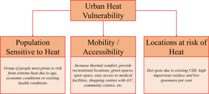
Unlike traditional approaches that focus predominantly on thermal measurements, the GUHVI incorporates a multidimensional understanding of vulnerability, drawing on the conceptual framework established by the Intergovernmental Panel on Climate Change, which defines vulnerability as the result of the interaction between exposure, sensitivity, and adaptive capacity. This integrated perspective is essential because it recognizes that extreme heat becomes dangerous not simply due to its intensity, but because of how it intersects with the characteristics of the populations and environments it affects.
A Multidimensional Structure: Exposure, Sensitivity, and Adaptive Capacity
The methodological architecture of the GUHVI is structured around three interconnected sub-indices, each capturing a different dimension of urban heat vulnerability while contributing equally to the overall score, thereby ensuring that no single factor disproportionately dominates the analysis. The first component, the heat exposure index, relies on land surface temperature data obtained through satellite imagery, enabling researchers to map spatial variations in heat intensity with a high degree of precision, particularly in urban areas where the so-called “urban heat island” effect can produce temperature differences of several degrees between neighborhoods.
The second component, the heat sensitivity index, introduces a critical layer of urban analysis by incorporating variables such as population density, vegetation coverage, and surface albedo, all of which influence how heat is absorbed, retained, and experienced within the built environment. Dense urban fabrics characterized by limited green spaces and extensive impermeable materials, such as asphalt and concrete, tend to trap heat more effectively, thereby amplifying thermal stress for residents, particularly in low-income neighborhoods where urban planning deficits are often most pronounced.
The third component, the adaptive capacity index, extends the analysis into the socioeconomic domain by including indicators such as access to healthcare services, infant mortality rates, and broader measures of social vulnerability, thereby acknowledging that the ability of individuals and communities to cope with extreme heat is deeply conditioned by structural inequalities and access to resources. By integrating these ten variables into a single composite index with equal weighting, the GUHVI ensures a balanced and holistic representation of urban heat vulnerability.
From a Local Prototype to a Global Analytical Framework
Originally conceived as a localized model for the city of Sydney by researcher Ryan Turner at the Centre for Urban Research of RMIT University, the index has since undergone a significant process of refinement and expansion through the collaboration of experts from multiple continents, including researchers from Mexico, Australia, China, the United States, Italy, Spain, the United Kingdom, Brazil, and New Zealand, all of whom are affiliated with the Global Observatory of Healthy and Sustainable Cities. Through this international effort, the GUHVI has been transformed into a globally applicable framework, capable of generating comparable results across diverse urban contexts while maintaining methodological consistency.
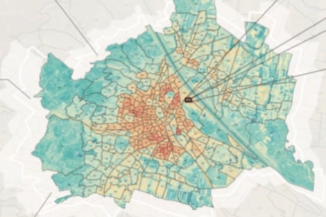
The index produces scores on a scale from zero to one hundred, where higher values correspond to greater levels of vulnerability and, consequently, higher potential impacts on human health during extreme heat events. One of the most significant innovations of the GUHVI lies in its spatial resolution, as it operates at the level of one-square-kilometer grid cells, thereby enabling the identification of vulnerability patterns not only between cities but also within them, revealing micro-scale disparities that are often invisible in aggregate analyses.
Revealing Global Patterns: The Case of Mexico City and Beyond
When applied to a sample of seventeen cities worldwide, the GUHVI revealed a striking and consistent pattern: a substantial proportion of urban populations tend to be concentrated in areas that are simultaneously the most vulnerable to heat, suggesting that the risks associated with extreme temperatures are not only significant but also structurally embedded within urban systems. In the case of the Mexico City metropolitan area, for instance, approximately sixty percent of residents live in zones classified as highly vulnerable, a finding that underscores the scale and urgency of the challenge.
Comparative results further illustrate the complexity of urban heat vulnerability, as the city of Maiduguri in Nigeria recorded the highest score, reflecting a combination of intense heat exposure, high sensitivity, and limited adaptive capacity, while Mexico City ranked second, with a notably lower exposure level than cities such as Los Angeles but significantly higher sensitivity and lower adaptive capacity. This contrast demonstrates that vulnerability cannot be understood through temperature alone, as cities with relatively moderate thermal conditions may still experience severe impacts due to urban form and social inequality, whereas wealthier cities with high exposure may mitigate some of their risks through stronger infrastructure and institutional capacity.
A practical example can be observed in the comparison between two neighborhoods within the same metropolitan area: one characterized by abundant tree cover, reflective building materials, and access to air-conditioned public facilities, and another defined by dense informal housing, minimal vegetation, and limited healthcare access. Even if both areas experience similar temperatures, the latter will exhibit significantly higher vulnerability due to its structural disadvantages, illustrating how the GUHVI captures the lived reality of heat risk.
From Diagnosis to Action: A Strategic Tool for Urban Policy
Beyond its analytical value, the GUHVI offers substantial potential as a tool for evidence-based policymaking, as it enables authorities to identify priority areas for intervention with a high degree of precision and to design targeted strategies that address the specific drivers of vulnerability within each context. By mapping vulnerability at the neighborhood scale, policymakers can move away from generalized, citywide approaches and instead focus on interventions that maximize impact, such as increasing urban green infrastructure, reducing the extent of heat-retaining surfaces, improving housing insulation and ventilation, and expanding access to healthcare services in high-risk areas.
This is particularly relevant in regions where extreme heat is already a major public health concern, as is the case in Mexico, where heatwaves have been associated with hundreds of illnesses and a significant number of deaths each year, primarily due to heatstroke and dehydration. The ability to prioritize interventions based on a nuanced understanding of vulnerability is therefore essential for optimizing the allocation of limited public resources, ensuring that investments are directed toward the populations and areas where they can generate the greatest benefits.
Furthermore, the index facilitates the identification of vulnerable demographic groups, such as young children and older adults, who are disproportionately affected by extreme heat, thereby supporting the development of targeted social policies and early warning systems. At the same time, its global scope enables cities to benchmark their performance, learn from best practices implemented elsewhere, and adapt successful strategies to their own specific conditions.
Toward More Resilient and Equitable Urban Futures
In an era in which extreme heat is expected to become an increasingly persistent and defining feature of urban life, the development of tools such as the GUHVI represents a critical step toward building cities that are not only more resilient but also more equitable, as it highlights the need to address the structural factors that underpin vulnerability rather than focusing solely on environmental symptoms. By revealing the hidden geographies of heat risk and the social inequalities that shape them, the index provides a powerful foundation for rethinking urban planning, public health, and climate adaptation strategies in an integrated and forward-looking manner, ultimately contributing to the creation of urban environments that can better protect their inhabitants in the face of a warming world.